
3.11 Carbonate Rates
Inputs: Carbonate accumulation pairs
Discussion: Rate of Carbonate Accumulation
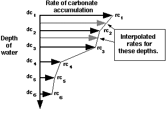
Figure 3.11.1. The rate of carbonate accumulation with water depth.
The surface slope that is maintained by carbonates is determined by the
combined effects of: 1.) the rate of in situ carbonate accumulation, and 2.) the depositional angle of the sediment
shed from the bank or reef crest as talus and turbidite. If the shape of
the carbonate rate curve determines that most of the carbonate will accumulate
in shallow water, the carbonate slope will be steep. If on the other hand,
the carbonate accumulation does not vary much with water depth, the carbonates
will maintain a uniform slope which parallels the underlying surface. This
slope may be steepened by sediment shed as talus and turbidite from the
reef or bank crest (see Carbonate Parameters, Section 3.16).

Carbonate rates are linearly interpolated between the depth-rate pairs
and are extrapolated from the intermediate input values up to sea level
or down to the sediment surface. Note that carbonate will not be deposited
beyond the defined depth range. Carbonate rate curves are defined for specific
times and are linearly interpolated between the defined times. If rates
at the start or end times are undefined, they are extrapolated from the
intermediate input curves.

Figure 3.11.2. Plotter for Carbonate Rates.
Carbonate rate-depth pairs are entered using the plotter (Figure 3.11.2) or data sheet (Figure 3.11.3). The plotter appears when Carbonate Rates is selected from the SEDPAK EDIT menu. Depths and rates of carbonate accumulation are defined for a specific time period. It is important to remember that the carbonate rate is linearly interpolated, not only between the specified depths on a particular curve, but also between the curves for the defined times.
During the application of the subroutine which deposits in situ carbonate, SEDPAK subdivides the primary Time Steps (see Section 3.03 Setup Parameters) of the simulation run into intermediate time steps of 1000 years. SEDPAK
then tracks the carbonate accumulation for each of these 1000 years substeps,
summing the total carbonate which accumulated during the primary Time Step. This functionally was developed to model the effects of small changes
in carbonate accumulation rate responding to changes in water depth as the
carbonate accumulates during a Time Step.

Figure 3.11.3. Data sheet for Carbonate Rates.
Inputs: Carbonate accumulation pairs

Percentages are linearly interpolated between sea level change-percent realized
pairs. The percentages are extrapolated from the intermediate input values
to the smallest and greatest sea level changes, if they are not defined
(Figure 3.12.1).

Figure 3.12.1. The response of carbonate accumulation to sea level change.
Figure 3.12.2 shows the Hardgrounds plotter and Figure 3.12.3 illustrates the Hardgrounds data sheet. From the example data in the plotter and data sheet, it can
be seen that within a time step, a 30 m sea level change would have a small
affect on carbonate accumulation, reducing it by 10% (90% realized). A sea
level change of 50 meters would reduce the carbonate accumulation by 50%.
Therefore, only 50% of the carbonate accumulation curve will be realized.
If the sea level change was 100 meters, then 20% of the carbonate accumulation
curve would be realized for that time step.

Figure 3.12.2. Plotter for Hardgrounds.

Figure 3.12.3. Data sheet for Hardgrounds.
3.13 Lagoonal Damping
Inputs: Lagoonal Damping

Discussion: Lagoonal Damping

Figure 3.13.1. Lagoonal Damping of carbonate production.
Build up crests or reefs are represented by the first location or column
in which carbonate growth reaches sea level, moving across the basin from
deep to shallow water. Once these locations are determined, the adjacent
areas are examined. If the depth of the sea is less than Wave Base (Section 3.03, Setup), then that area is considered to be a lagoon or epeiric shelf and its
rate of accumulation may be damped accordingly (Figure 3.13.1). Otherwise,
the area is considered to be an open basin and no damping will occur.
A lagoon can be simulated through the use of the Lagoonal Damping function. A Lagoonal Damping curve is created by selecting Lagoonal Damping from the SEDPAK EDIT menu. Figure 3.13.2 shows the Lagoonal Damping plotter and Figure 3.13.3 illustrates the Lagoonal Damping data sheet. If a curve does not already exists, select New Curve from the Curves pull down menu on the plotter. A data sheet will appear.
Lagoonal Damping data is entered in pairs as "distance from the reef" and "damping rate."
The distance from the reef is in units of kilometers or miles, and the damping
rate is a percentage by which the carbonate accumulation curve is reduced.
The same Lagoonal Damping curve is used for all time steps. Percentages are linearly interpolated
between distance-damping pairs. Extrapolation of the Lagoonal Damping values does not occur. NB: Lagoonal Damping will occur shoreward of a reef or carbonate "build up" where the water
depth is shallower than Wave Base. If Wave Base is deeper than the depth of water across the section being simulated, then
that section will be considered to be of "lagoonal" depth and Lagoonal Damping will be applied to the entire section. This effect can be modified by setting
the Wave Base to a shallower depth.

Figure 3.13.2. Plotter for Lagoonal Damping.
The Lagoonal Damping function is used to form a lagoon to the lee of
a reef or margin build up. However, as a result of pre-existing topography,
a lagoon may occur even if Lagoonal Damping is turned off and 100% carbonate
accumulation is applied across the basin. Within SEDPAK, a reef is considered
to be any carbonate build up close to deep water which reaches sea level. The
depth of the lagoon will depend on the water depth, the carbonate accumulation
curve, the rate of subsidence and sea level variation, as well as the amount
of eroded material which enters the lagoon as talus and turbidite.

Figure 3.13.3. Data sheet for Lagoonal Damping.
The amount of eroded carbonate moving off a reef or build up is specified
by the Percent to Sea variable which is accessed from the Carbonate Parameters dialog (Section 3.16). Entering a high percentage for this parameter will put more talus or
turbidite into the basin and less into the lagoon. Conversely, a low percentage
will put more talus or turbidite into the lagoon, causing it to fill more
quickly close to the reef (Section 3.16).
3.14 Wave Damping
Inputs: Carbonate accumulation wave damping depths and rates

The wave damping is interpolated linearly between depth-rate pairs and is
extrapolated from the intermediate input values up to sea level or down
to the sediment surface. The values are linearly interpolated between the
specified Wave Damping locations, but are not extrapolated either seaward or landward of the defined
curve positions (Figure 3.14.2). Remember from time-step to time-step as
relative sea level changes so the zone of Wave Damping will migrate back and forth across the shelf landward of the location at
which Wave Base intersects the sediment surface (Figure 3.14.2). The program will NOT RUN if only one location is set. Similarly Wave Damping will not be applied if the deepest water seaward in the basin is shallower
than the Wave Base. For instance at Time 1 on Figure 3.14.2 Wave Base lies below the sediment surface at the seaward edge of the simulation so
no Wave Damping can occur. At Times 2 through 4 Wave Damping occurs because the sediment surface at the seaward edge of the simulation
lies below Wave Base. This is because SEDPAK must find Wave Base at the most seaward defined location of Wave Damping to begin applying the Wave Damping function (Figure 3.14.2). As can be seen in Figure 3.14.2 when sea level
position changes relative to the depositional surface, so the location of
the zone over which wave damping takes place changes its horizontal location
through time. This is because when sea level position relative to the depositional
surface changes, so the location of the intersection of Wave Base with this surface does too. Wave damping curves are not required to use
the program but if Wave Damping is desired, then at least two locations and their curves must be specified.

Figure 3.14.1. Wave Damping of carbonate accumulation by waves from the
left.
Wave Damping enables carbonate production to be reduced locally as a function of water
depth when wave energy is very intense. The amount of carbonate removed
is prescribed by direct subtraction from the carbonate accumulation rate.
Production rates will be reduced only at the locations specified and can
remain high at other locations. Similar to winnowing, the amount of carbonate
damped at a specific location can be varied through the water column. Therefore,
the amount of carbonate deposited may be suppressed both at various locations
and at various depths for these locations. By varying Wave Damping across a shelf, it is possible for a carbonate margin to prograde in the
more sheltered portions of the shelf. To avoid abrupt step-like variations
on the simulation output associated with both Wave Damping, more than two curves should be used and their data values should vary smoothly.
An example of the use of Wave Damping would be to produce backstepping of a high energy carbonate margin during a large rise in sea level. If the rate of carbonate accumulation is reduced gradually with depth, the Wave Damping function can be used to maintain a high rate of carbonate accumulation in shallow water and a rapid reduction in accumulation rates with greater depths. Therefore, a rapid, large sea level rise can result in little or no carbonate production in the deeper, seaward portions of the shelf, but will enable the rapid accumulation of carbonate to take place in a shallower, more leeward position across the shelf.
WARNING: If Wave Damping is specified so that the damping rate at Wave Base is greater than the carbonate accumulation rate, a marginal build up will develop seaward of Wave Base. This occurs because Wave Damping has no effect below Wave Base and is reduced to zero. This build up geometry can be avoided by reducing Wave Damping to zero at or above Wave Base. If an offshore buildup forms, the rates on the damping curve should be reduced in deeper water until this effect is removed.

Figure 3.14.2. As sea level position changes so does the location of Wave Base and the zone of Wave Damping.

Figure 3.14.3. Plotter for Wave Damping of carbonates by waves from the
left.
To enter Wave Damping values, select either "...from the Left" or "...from the Right" from the Wave Damping cascade menu. Wave Damping from both sides may be used for the same simulation, but curves for the
two directions must be created separately (Figure 3.14.3). Select New Curve from the Curves pull down menu on the plotter (Figure 3.14.3) and enter the location for
the curve on the data sheet. Create the damping curve at that location by
entering the values in the data sheet (Figure 3.14.4) or directly on the
plotter (after entering the first point in the data sheet and selecting Apply). Don't forget to select OK on the plotter (and data sheet, if used) and save the file using Save from the File pull-down menu on the SEDPAK EDIT panel.

Figure 3.14.4. Data sheet for Wave Damping of carbonates by waves from the
left.